Location: Steni Evias
Date: 30/11/2025
Time: 09:30
Distance: 14,6km
Stations: 4
Alt. gain/loss: +840m | -840m
Lowest point: 408m
Highest point: 1137m
Registration Fee
Basic Pack 15 €
Plus Pack 35 €
Benefits
| Dirfys Paths 15km | BASIC PACK | PLUS PACK |
|---|---|---|
| runner number | ||
| Digital timing with chip | ||
| Fuel stations | ||
| medal | ||
| Provision of water, sports drinks, soft drinks (at fuel stations) | ||
| first aid services and medical care | ||
| photos | ||
| Techical long sleeve tshirt Anthrax | ||
| Cost | 15 € | 35 € |
Route description
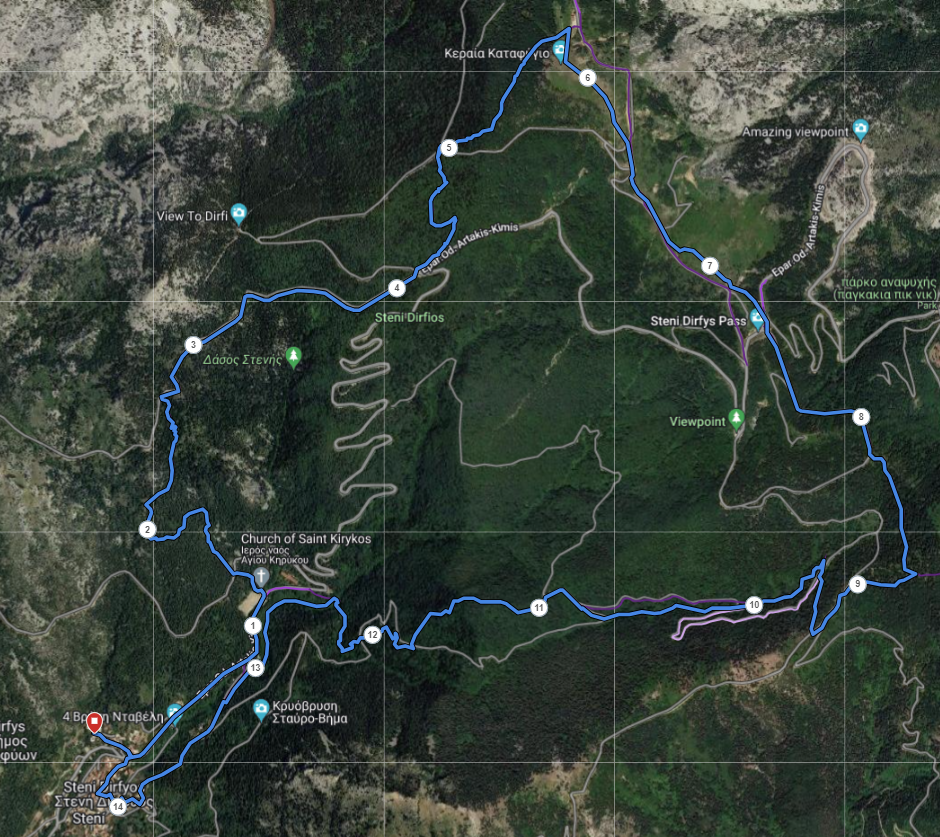
The race starts from Stenis school at an altitude of 400m. The route moves on asphalt for 1.5 km to the stadium of Steni where we turn left to enter a path (Σ1). The path is uphill for 1.5km and ends on a dirt road where after 1km the 1st feed station is located (4.2km). The route continues on the “Elatias” trail to the mountain refuge at an altitude of 1110m which will be the 2nd feeding station (5.8km). From the shelter, it starts downhill on a dirt road for 2.5km to Rachi Syka to rejoin the path (S3). The 3rd feed station is at 8.7 km. The route continues with a long downhill for 2km and requires special attention as it has difficult sections on the way down. We continue with an easy river crossing and reach the 4th feed station (12.8km). The last 2 km pass through the village to the finish at Stenis school.
Stations
FOOD
| POI | Description | Total Distance | Νερά | Αλμυρά | Coca Cola | Ethicsport gel | Ηλεκτρολύτες | Μαγνήσιο | Αποξηραμένα φρούτα | μπανάνα | σοκολάτα | Μπάρες | energy drink | Πουράκια |
|---|---|---|---|---|---|---|---|---|---|---|---|---|---|---|
| Start | Race start | 0 | ||||||||||||
| CP1 | K. Karakitsios – D.Kostopoulos station | 4.1 | ||||||||||||
| CP2 | Sevah station M.Nikolalou Refuge | 5.8 | ||||||||||||
| CP3 | Sideritis station | 8.7 | ||||||||||||
| CP4 | L. Karagianni station | 12.8 | ||||||||||||
| End | Race End | 14.6 |
STATISTICS
| POI | Description | Altitute | Total Distance | Total D+ | Total D- | Part. Distance | Part. D+ | Part. D- |
|---|---|---|---|---|---|---|---|---|
| Start | Race start | 431 | 0 | 0 | 0 | 0 | 0 | 0 |
| CP1 | K. Karakitsios – D.Kostopoulos station | 863 | 4.1 | 449 | 17 | 4.1 | 449 | 17 |
| CP2 | Sevah station M.Nikolalou Refuge | 1110 | 5.8 | 696 | 17 | 1.6 | 247 | 0 |
| CP3 | Sideritis station | 1015 | 8.7 | 767 | 183 | 2.9 | 71 | 166 |
| CP4 | L. Karagianni station | 483 | 12.8 | 800 | 746 | 4.1 | 33 | 563 |
| Stop | Race End | 431 | 14.6 | 837 | 837 | 1.7 | 37 | 91 |
Route Map
Route animation
Kilometer marking of the race