Information

Location: Steni Evias
Date: 30/11/2025
Time: 09:00
Distance: 32,5km
Station: 7
Alt gain/loss: +1506m | -1506m
Lowest point: 410m
Highest point: 1155m
Registration Fee:
Basic Pack 20€
Plus Pack 50€
Benefits & cost
| Iraios Athlos 30km | BASIC PACK | PLUS PACK |
|---|---|---|
| runner number | ||
| Digital timing with chip | ||
| Fuel stations | ||
| medal | ||
| Provision of water, sports drinks, soft drinks (at fuel stations) | ||
| first aid services and medical care | ||
| photos | ||
| Anthrax windproof running jacket | ||
| Cost | 20 € | 50 € |
ITRA – UTMB


Route description
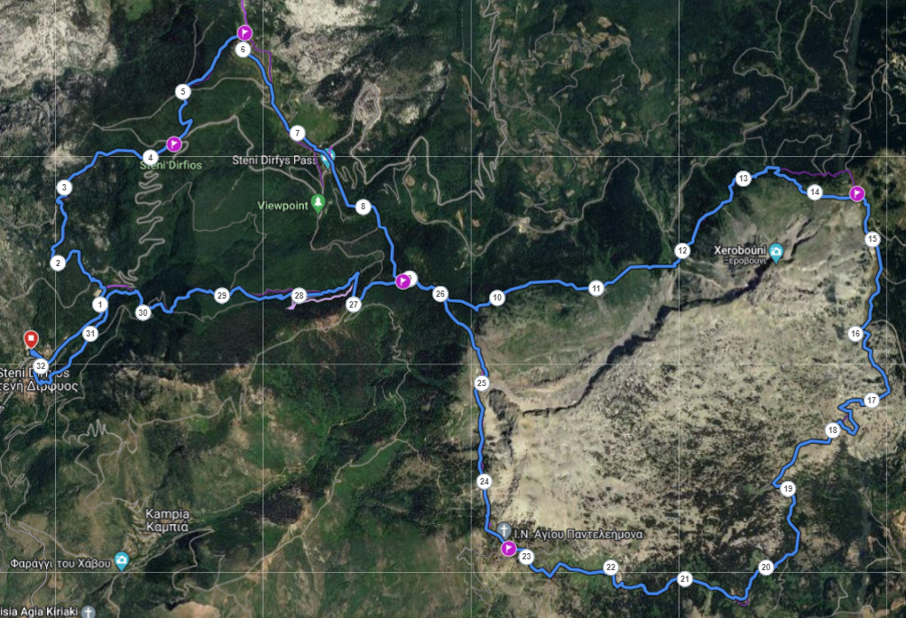
The length of the route is 32.5km with a maximum altitude difference of 1,603m. Apart from 1500m at the start and 1500m at the finish which are on asphalt, the rest of the route is on technical trails and dirt mountain road. The start and finish of the race take place at Stenis primary school.
The race starts from Stenis Primary School at an altitude of 400m. The route moves on asphalt for 1.5 km to the stadium of Steni where we turn left to enter the path (Σ1). The path is uphill on passable terrain for 1.5km and ends on a dirt forest road where after 1km the 1st feed station is located at 4.2km. The route continues on the “Elatias” path, a beautiful part of the race where the athletes move through a dense forest of wild chestnuts, plane trees and Capellinian fir, up to the mountain refuge ¨Mich. Nikolaou of EOS Chalkida at an altitude of 1117m. which will be the 2nd fuel station at 5.8 km. (Sevach).
From the refuge, it starts downhill on a forest dirt road with 2 small technical sections for 2.5 km to Rachi Syka to re-enter a dense forest path (Xirovounio Path X1). The 3rd feed station is at 8.7 km. – 796 m. (Siderite). It is at this point that the two major routes diverge. For the 30 km we move east, while the athletes for the 15 km turn west. So we continue east on a path with passable terrain and some stone, with ups and downs on a gentle slope, passing on our right the entire ridge of Xirovouni with its famous climbing routes. Along the route there are 2 springs with clean drinking water, the Templa spring at 10km and the Konisma spring at 13km.
From this point onwards, the most intense and strenuous ascent of the route begins with +200m. positive altitude for 1 km on a stone path, traversing under the Portaris peak, until we come out on an asphalt road where the 4th supply station will be located at 14.3 km. – 1138 m. (A. Sykaris). Here is the highest point of the race.
For 1km we move on the asphalt road and then turn right to now enter the alpine parts of the route where the terrain alternates from forest dirt roads to very rocky and technical paths. Be careful at the fork in the dirt road at 19 km. to move to the right heading West where after 3km. there is a spring with drinking water and after 4 km. we arrive at the beautiful chapel of Agios Panteleimon. There will also be the 5th fuel station at 23.4 km. – 1070 m. (The 5 heroes of Mistro). Throughout this route we move on the south-eastern side of Xirovouni and in fact we go around it seeing the wild beauty of the mountains in the area
After 3.5 km. in quite technical terrain with sara and after we have re-entered the Xirovouni forest path we meet the 6th feeding station at 26.6 km. – 1016 m. (Siderite). The route from this point continues on the S3 path with a long descent for 3.5km which requires special attention as it has difficult parts to descend with steep slopes. We continue with an easy river crossing and reach the 7th feed station at 30.8km. – 488 m. (Lela Karagianni)..
The last 1.9km pass through the village to the finish line at Stenis Primary School. 30 enjoyable but at the same time demanding kilometers in the beautiful forest and alpine parts of Mount Dirfi and Xirovouni.
Stations – Food
| POI | Description | cut off time | Total Distance | Νερά | Αλμυρά | Ethicsport gel | Coca Cola | Ηλεκτρολύτες | Μαγνήσιο | Κεικ | Αποξηραμένα φρούτα | Μπανάνα | Σοκολατάκι | Μπάρες | energy drink | Πουράκια |
|---|---|---|---|---|---|---|---|---|---|---|---|---|---|---|---|---|
| Race Start | 0 | |||||||||||||||
| CP1 | K. Karakitsios – D.Kostopoulos station | 4.2 | ||||||||||||||
| CP2 | Sevah station M.Nikolalou Refuge | 5.8 | ||||||||||||||
| CP3 | Sideritis 1 station | 8.7 | ||||||||||||||
| CP4 | A. Sykaris Station | 14.5 | ||||||||||||||
| CP5 | 5 Heroes of Mistros | 23.4 | ||||||||||||||
| CP6 | Sideritis 2 Station | 26.6 | ||||||||||||||
| CP7 | L. Karagianni station | 30.8 | ||||||||||||||
| Race End | 32.5 |
Stations – Statistics
| POI | Description | Altitute | cut off time | Total Distance | Total D+ | Total D- | Part. Distance | Part. D+ | Part. D- |
|---|---|---|---|---|---|---|---|---|---|
| Start | 425 | 0 | 0 | 0 | 0 | 0 | 0 | ||
| CP1 | K. Karakitsios – D.Kostopoulos station | 862 | 4.2 | 459 | 22 | 4.2 | 459 | 22 | |
| CP2 | Sevah station M.Nikolalou Refuge | 1117 | 5.8 | 714 | 22 | 1.6 | 255 | 0 | |
| CP3 | Sideritis 1 station | 1006 | 8.7 | 796 | 215 | 2.8 | 82 | 193 | |
| CP4 | A. Sykaris Station | 1138 | 14.5 | 1099 | 386 | 5.8 | 303 | 171 | |
| CP5 | 5 Heroes of Mistros | 1070 | 23.4 | 1370 | 725 | 8.8 | 271 | 339 | |
| CP6 | Sideritis 2 Station | 1016 | 26.6 | 1461 | 871 | 3.2 | 91 | 146 | |
| CP7 | L. Karagianni station | 488 | 30.8 | 1480 | 1417 | 4.1 | 19 | 546 | |
| Stop | 425 | 32.5 | 1506 | 1506 | 1.6 | 26 | 89 |
Route Map
Route animation
Kilometer marking of the race